


介绍 GPS Air Navigator
GPS Air Navigator is an application for VFR Air Navigation :: Air Nav.
Follow us on https://www.facebook.com/gpsairnavigator!
Main features:
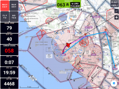
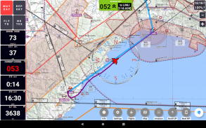
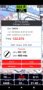
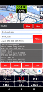
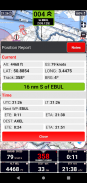
• real-time GPS moving map
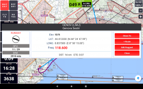
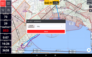
• graphical visualization of country air space
• navigation with True or Magnetic North
• High Quality VFR Aeronautical Charts (from Flyermaps.com) for Portugal, Spain, Argentina, Chile, Colombia, Iceland, Uruguay and Venezuela
• free OpenStreetMap maps for all countries
• USA Sectional VFR Charts (generated from FAA VFR Raster Charts)
• WAC and REA Charts from Brazil (thanks to DECEA-Brazil)
• free OpenFlightMaps Charts from Netherlands, Poland, Croatia, Czech Republic, Belgium, Germany, Denmark, Sweden, Bulgaria, Hungary, Slovenia, Austria, Romania and Switzerland (thanks to the Openflightmaps Association)
• airspace information for Portugal with daily updates (integrated with FuaFlex service - www.cavok.pt)
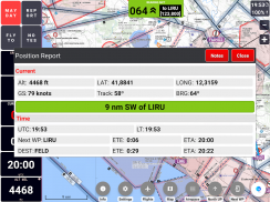
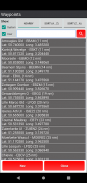
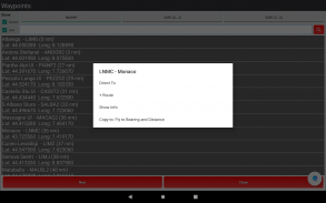
• database with more than 56.000 system waypoints
• create and manage your own user waypoints
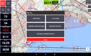
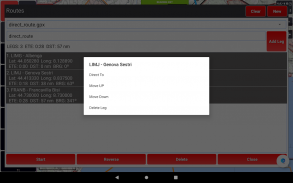
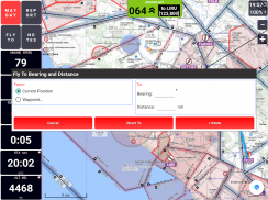
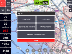
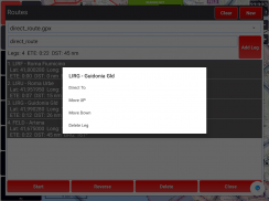
• create and manage your routes and legs
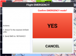
• MAYDAY button: send an automatic SMS with current location (only in devices that support this feature) and activation of a route to the nearest waypoint
• Course with two navigation modes: a) visualization of the course you have to follow to reach the next waypoint or; b) visualization of how many degrees you have to turn to reach the next waypoint, while the arrow shows in which direction the point is in relation to the direction of your flight
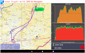
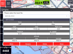
• show real-time flight tracks
• save flight tracks to a GPX file for offline processing (visualize in specific apps or inside the GPS Air Navigator)
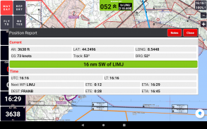
• visualize your flight stats and share them on Facebook, e-mail, Instagram and so on
• only one licence needed for all your Android devices
After install, you can try the app with the following limitations:
• you can save only two user waypoints;
• the app closes after 15 minutes of usage.
If you like GPS Air Navigator, you can buy a licence using the button Buy inside the app, to use it without limitations.
Enjoy GPS Air Navigator!
GPS Air Navigator是VFR Air Navigation :: Air Nav的应用程序。
在https://www.facebook.com/gpsairnavigator上关注我们!
主要特点:
•实时GPS移动地图
•国家空域的图形可视化
•使用真北或磁北导航
•适用于葡萄牙,西班牙,阿根廷,智利,哥伦比亚,冰岛,乌拉圭和委内瑞拉的高质量VFR航空图(来自Flyermaps.com)
•适用于所有国家的免费OpenStreetMap地图
•美国分区VFR图表(从FAA VFR栅格图表生成)
•巴西的WAC和REA图表(感谢DECEA-Brazil)
•来自荷兰,波兰,克罗地亚,捷克共和国,比利时,德国,丹麦,瑞典,保加利亚,匈牙利,斯洛文尼亚,奥地利,罗马尼亚和瑞士的免费OpenFlightMaps图表(感谢Openflightmaps协会)
•葡萄牙的空域信息,每日更新(与FuaFlex服务集成-www.cavok.pt)
•具有超过56.000个系统航路点的数据库
•创建和管理您自己的用户航点
•创建和管理您的路线和路段
•MAYDAY按钮:发送带有当前位置的自动SMS(仅在支持此功能的设备中)并激活到最近航路点的路线
•具有两种导航模式的课程:a)可视化您要到达下一个航点的课程的信息;或b)可视化您必须旋转多少度才能到达下一个航点,而箭头则显示了该点相对于飞行方向所处的方向
•显示实时飞行轨迹
•将飞行轨迹保存到GPX文件中以进行离线处理(在特定应用中或在GPS Air Navigator中可视化)
•可视化您的航班状态,并在Facebook,电子邮件,Instagram等上共享它们
•您所有的Android设备只需要一个许可证
安装后,您可以尝试使用以下限制的应用程序:
•您只能保存两个用户航路点;
•使用15分钟后,应用程序关闭。
如果您喜欢GPS Air Navigator,则可以使用应用内的购买按钮购买许可证,以无限制地使用它。
享受GPS Air Navigator!
GPS Air Navigator - 版本4.0.21c
(15-12-2020)
GPS Air Navigator - APK信息
APK版本: 4.0.21c程序包: com.nksoftware.gpsairnavigator同类应用
您可能还会喜欢……


